

How to Assess the Geological Potential of a Mineral Property (A Brief Complete Guide for Beginners)
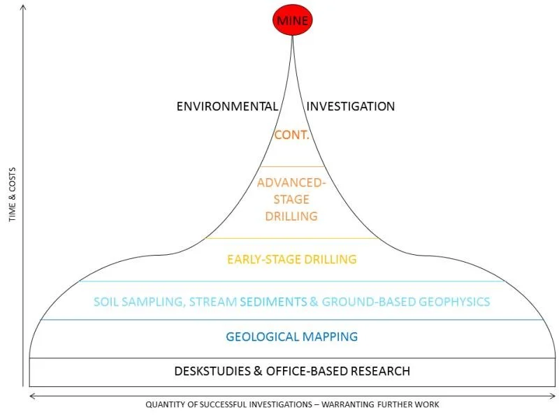
Conceptual diagram of the mineral exploration process, showing progression from early-stage evaluation through drilling and development toward a producing mine. Source: Geological Survey Ireland (GSI)
What Is Geological Potential?
Geological potential refers to the likelihood that a mineral property hosts a mineral deposit of sufficient size, grade, and continuity to justify exploration and, ultimately, economic development.
At its core, assessing geological potential is about answering three fundamental questions:
Is the right geological system present?
Did the processes required to form mineralization occur here?
Has that mineralization been preserved and concentrated in a way that can be discovered and extracted?
A property must satisfy all three conditions to be considered prospective.
Understanding Mineral Systems (The Foundation)
Every mineral deposit forms through a specific geological process known as a mineral system. These systems require a combination of:
Source – Where the metals originated
Transport – How the metals moved (fluids, melts, groundwater)
Trap – Where and why the metals were deposited
Preservation – Whether the deposit survived erosion or destruction
If any one of these components is missing, the likelihood of a viable deposit drops significantly.
For example:
Gold in epithermal systems is transported by hydrothermal fluids and deposited along faults and fractures (typically)
Lithium in clay systems forms in closed basins where volcanic ash alters and concentrates in sediments
Understanding the type of system you are targeting is the first step in evaluating any property.
Key Geological Factors That Control Potential
1. Lithology (Rock Type)
Different minerals form in specific rock types. Identifying the correct host rock is critical.
Volcanic tuffs and clays → lithium potential
Carbonates → potential for replacement deposits
Intrusives → porphyry systems
If the right rock types are not present, the probability of success is low.
2. Structure (Faults and Deformation)
Structure controls where mineralization occurs and how it is concentrated.
Faults act as pathways for mineralizing fluids
Fractures create permeability
Basin faults control sediment accumulation and trap environments
In many systems, structure is the primary control on mineralization.
3. Alteration
Alteration is the chemical fingerprint of a mineral system.
Clay alteration may indicate hydrothermal activity
Silicification can signal fluid pathways
Oxidation may reflect near-surface processes
Recognizing alteration helps confirm that mineralizing processes were active.
4. Mineralization Indicators
Direct or indirect evidence of mineralization includes:
Elevated assay values
Visible minerals (e.g., sulfides, quartz veining)
Pathfinder elements
Even weak mineralization can indicate proximity to a larger system.
5. Geometry and Scale
A deposit must be large enough to matter.
Thickness of mineralized zones
Lateral continuity
Depth extent
Small, isolated occurrences rarely develop into economic deposits without scale.
Geological Potential vs. Economic Potential
It is important to distinguish between:
Geological Potential → Is the deposit there?
Economic Potential → Can it be mined profitably?
A property may have strong geological potential but fail economically due to:
Low grades
Excessive depth
Poor metallurgy
Lack of infrastructure
Early-stage exploration focuses primarily on geological potential, with economic factors becoming more important as the project advances.
Why Most Properties Fail
Most mineral properties do not lack mineralization—they lack a complete and well-understood geological system.
Common issues include:
Incomplete data
Misinterpreted geology
Lack of structural understanding
Over-reliance on isolated results
Assessing geological potential is ultimately about reducing uncertainty by building and testing a coherent geological model.
The Role of Data Integration
No single dataset is enough to define geological potential. Instead, geologists integrate:
Surface mapping
Historical data
Geophysics
Drilling results
The goal is to create a working geological model that explains:
Where mineralization should occur
Why it should be there
How it can be tested
This model evolves as new data is collected and is the foundation of all successful exploration programs.
A Practical Way to Think About It
A useful way to think about geological potential is:
A mineral property has strong geological potential when multiple independent lines of evidence all point toward the presence of a mineral system.
These lines of evidence might include:
Favorable regional setting
Correct host rocks
Structural controls
Supporting geophysical anomalies
Early drilling or sampling results
The more of these factors that align, the higher the probability of discovery.
The Step-by-Step Process Used by Professional Geologists
1. Evaluate Regional Geological Setting
The first step is understanding the broader geological environment:
Tectonic setting (e.g., basin, volcanic arc, craton)
Known deposit types in the region
Structural trends and mineral belts
A strong regional setting significantly increases the probability of discovery. Many projects can be quickly eliminated at this stage if they lack a favorable geological environment.
2. Review Historical Data
Before any fieldwork begins, all available data should be compiled and analyzed:
Previous drilling records
Assay data and sampling results
Historical reports and maps
Past geophysical surveys
This step often reveals overlooked opportunities or prevents duplication of failed exploration efforts.
3. Conduct Surface Mapping and Field Evaluation
Fieldwork is critical for validating geological concepts:
Lithology identification
Alteration mapping
Structural measurements (faults, fractures, folds)
Float tracing and source identification
Surface geology provides the first real confirmation of whether a mineral system may be present.
4. Analyze Structural Controls and Basin Geometry
Structure often controls mineralization:
Fault zones acting as fluid pathways
Basin architecture and sedimentary traps
Stratigraphic controls on mineral deposition
For example, in clay-hosted lithium systems, closed basin environments and fault-controlled depocenters are key indicators of potential.
5. Integrate Geophysical Data
Geophysics helps visualize what cannot be seen at surface:
Gravity surveys → basin depth and structure
TEM (Transient Electromagnetics) → conductive units such as clays or brines
Induced Polarization (IP) → sulfide mineralization
Geophysics is a powerful tool, but it must be interpreted alongside geology. Over-reliance on a single dataset is a common mistake.
6. Generate and Rank Drill Targets
Once all data is integrated:
Define specific drill locations
Rank targets based on geological confidence
Balance risk vs. potential reward
This step transforms a conceptual project into a testable exploration program.
7. Drill and Validate the Model
Drilling is the only way to confirm geological potential:
Confirm lithology and stratigraphy
Measure thickness of mineralized zones
Analyze grade through assays
Results are used to refine the geological model and guide future drilling.
8. Apply Economic Filters
Even if mineralization is present, economic viability must be considered:
Depth to target
Grade and thickness
Metallurgical characteristics
Infrastructure and access
Permitting environment
A project must meet both geological and economic criteria to move forward.
Real-World Application: Nevada Lithium Exploration
In Nevada, evaluating lithium clay projects requires a combination of:
Basin-scale geological interpretation
Identification of lithium-bearing claystone units
Integration of geophysics (particularly TEM for conductive clays)
Strategic drilling to test depth and continuity
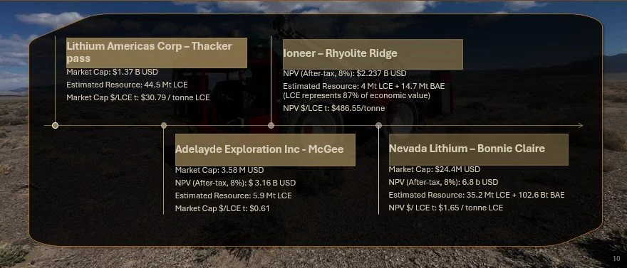
Project comparisons showing how geological potential (resource size and scale) translates into economic value, including market cap and NPV per tonne of LCE.
In many cases, early-stage models rely heavily on indirect data such as gravity surveys. However, the true extent and depth of lithium-bearing units can only be confirmed through drilling. This is why a flexible exploration model—one that evolves with new data—is critical to success.
Common Mistakes in Assessing Mineral Properties
Many projects fail due to avoidable errors:
Over-reliance on a single dataset (e.g., geophysics without drilling)
Ignoring structural controls on mineralization
Focusing on grade without considering thickness
Misinterpreting geophysical anomalies
Not drilling deep enough to fully test the system
Failing to integrate all available data into a coherent model
Avoiding these mistakes can significantly improve exploration success rates.
Frequently Asked Questions
What makes a mineral property valuable?
A valuable property combines favorable geology, confirmed mineralization, sufficient scale (thickness and extent), and economic viability.
Can geophysics replace drilling?
No. Geophysics can guide exploration, but drilling is required to confirm mineralization and validate models.
How much data is needed before drilling?
Enough to define a geological concept and generate targets, but not so much that time and capital are wasted delaying drilling.
What is the biggest risk in early-stage exploration?
Misinterpreting data and drilling in the wrong location due to an incomplete or incorrect geological model.
Sign Up For our Article Mailing List to receive more articles like this!