

What is a TEM Survey in Mineral Exploration?
A Transient Electromagnetic (TEM) survey is a geophysical method used in mineral exploration to map variations in the electrical conductivity of the subsurface. By measuring how the ground responds to a rapidly changing electromagnetic field, geologists can identify buried geological structures, sedimentary basins, groundwater zones, and mineralized horizons that may host valuable resources.
TEM surveys are widely used in exploration for lithium, base metals, uranium, and groundwater, particularly in areas where deposits occur beneath cover such as alluvium or volcanic sediments. The technique is especially valuable in basin environments where drilling alone provides limited information between widely spaced holes.
How a TEM Survey Works
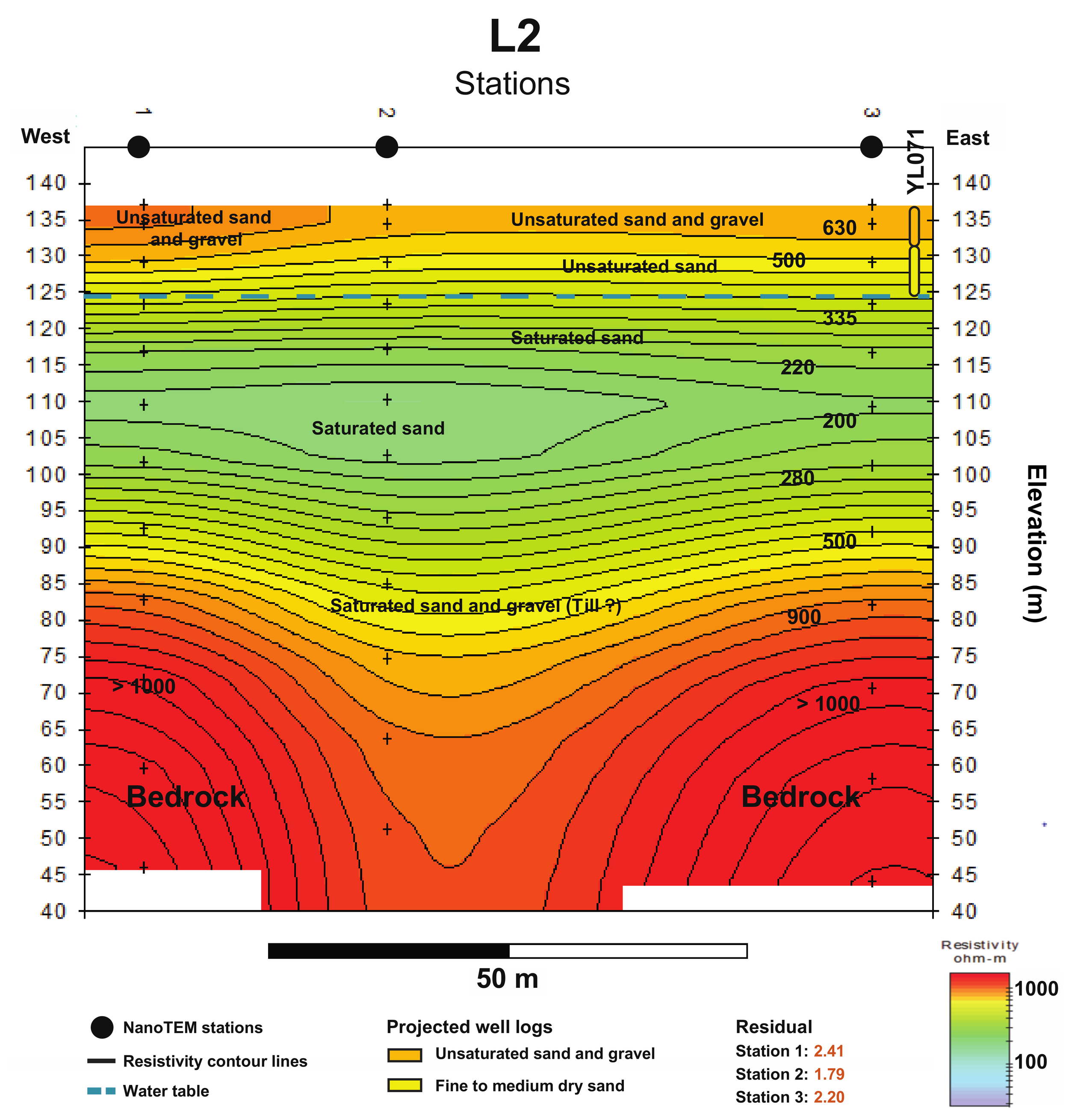
A picture of an example TEM line survey interpretation https://www.mdpi.com/2076-3263/11/10/415
A TEM survey operates by transmitting a controlled electromagnetic signal into the ground and then measuring how that signal decays over time.
The process typically follows these steps:
A transmitter loop is placed on the ground
A large loop of wire is laid out on the surface and connected to a transmitter unit.An electrical current is pulsed through the loop
When current flows through the loop it creates a magnetic field that penetrates the ground.The current is rapidly switched off
When the current stops, the collapsing magnetic field induces electrical currents in the subsurface known as eddy currents.A receiver measures the decay of these currents
Conductive materials allow the currents to persist longer, while resistive materials cause them to decay more quickly.
By measuring how fast the signal decays and how strong it is at different time intervals, geophysicists can determine the electrical conductivity of rocks at different depths.
What TEM Surveys Detect
Different rock types and geological materials conduct electricity differently. TEM surveys exploit these differences to map subsurface geology.
Materials that often appear more conductive include:
Clay-rich sediments
Saline groundwater
Sulfide mineralization
Graphitic units
Certain alteration zones
Materials that appear more resistive include:
Dry sands and gravels
Volcanic rocks
Massive carbonates
Silicified zones
These contrasts allow geologists to interpret buried structures, basin geometry, and potential mineralized horizons.
Why TEM Surveys Are Important in Exploration
One of the biggest challenges in mineral exploration is understanding what lies beneath surface cover. In many regions, bedrock geology is hidden beneath layers of sediment, volcanic rocks, or alluvium.
TEM surveys help exploration teams:
Map basin depth and shape
Identify faults and structural corridors
Detect conductive sedimentary units
Locate potential mineralization zones
Improve drill targeting
Because TEM surveys can investigate hundreds of meters to over a kilometer below the surface, they are particularly valuable in deep basin environments where drilling costs are high.
TEM Surveys in Lithium Exploration
TEM surveys have become increasingly important in exploration for lithium-bearing clay deposits in closed basin environments.
In these settings, lithium mineralization often occurs within tuffaceous claystone layers deposited in ancient lake basins. These clay-rich sediments tend to be more conductive than surrounding units, allowing TEM surveys to highlight the basin architecture and the horizons most likely to host lithium enrichment.
By mapping conductive layers across large areas, TEM surveys can help geologists:
Trace lithium-bearing sedimentary units
Identify structural basins that could host mineralized clays
Connect isolated drill results into a larger geological model
Prioritize new drilling targets
This approach has become a key exploration tool in several Nevada lithium districts.
TEM Surveys in Gold Exploration
Transient Electromagnetic (TEM) surveys are increasingly used in gold exploration to detect conductive geological features that may be associated with gold mineralization. While gold itself is not conductive, the geological environments that host gold deposits often contain conductive minerals or alteration zones that can be detected using electromagnetic methods.
Because of this, TEM surveys are particularly useful for identifying structures, alteration zones, and sulfide-rich horizons that can act as vectors toward gold mineralization.
Applications in Different Gold Deposit Types
TEM surveys are particularly useful in several types of gold systems.
Carlin-Type Gold Systems
In Carlin-type gold deposits, such as those found in Nevada, gold is typically hosted in silicified and decalcified carbonate rocks containing fine-grained sulfides. These sulfide minerals can produce subtle conductivity anomalies.
TEM surveys can help:
Map fault zones that acted as fluid pathways
Detect sulfide-rich horizons
Identify structural traps beneath basin cover
Although other methods like gravity and magnetics are commonly used in Carlin exploration, TEM can provide additional information about conductive alteration zones.
Epithermal Gold Systems
In epithermal gold deposits, conductivity contrasts often arise from:
Clay alteration zones
Sulfide veins
Hydrothermal breccias
Structural conduits
TEM surveys can highlight hydrothermal alteration halos surrounding gold-bearing veins, helping exploration teams identify prospective structures even where veins are not exposed at surface.
Volcanogenic Massive Sulfide (VMS) and Gold-Rich Sulfide Systems
TEM surveys are extremely effective in detecting massive sulfide bodies, which are highly conductive. In systems where gold is associated with sulfides—such as some VMS deposits—TEM can directly detect the sulfide host rock.
These deposits often produce strong conductivity anomalies that stand out clearly in TEM data.
Advantages of TEM Surveys
Compared with many other geophysical methods, TEM surveys offer several advantages for exploration programs:
Depth penetration – capable of imaging hundreds of meters to over a kilometer below surface.
Sensitivity to conductive materials – excellent for mapping clay-rich sediments and alteration zones.
High resolution – provides detailed information about vertical layering.
Efficiency – large areas can be surveyed relatively quickly.
For these reasons, TEM surveys are often used early in exploration programs to develop a basin-scale geological framework before extensive drilling begins.
Limitations of TEM Surveys
While Transient Electromagnetic (TEM) surveys are a powerful geophysical tool, they have several limitations that exploration teams must consider when interpreting results.
TEM does not detect minerals directly. The method measures electrical conductivity in the subsurface, not the presence of specific metals. As a result, conductive anomalies may represent clays, saline groundwater, graphite, sulfide minerals, or other materials unrelated to economic mineralization.
Non-unique interpretations are common. Multiple geological materials can produce similar conductivity responses. Without supporting geological data, it can be difficult to determine the exact cause of an anomaly.
Resolution decreases with depth. While TEM can image hundreds of meters to more than a kilometer below surface, deeper signals become broader and less precise, which can make it challenging to define exact geological boundaries.
Cultural interference can affect data quality. Powerlines, pipelines, fences, and other man-made infrastructure can generate electromagnetic noise that interferes with measurements.
Geology may mask targets. Thick conductive overburden, highly conductive sediments, or saline groundwater can obscure deeper features, reducing the ability to detect underlying structures or mineralized zones.
Because of these limitations, TEM surveys are most effective when integrated with other exploration methods such as geological mapping, geochemistry, gravity surveys, magnetic surveys, and drilling. When used as part of a multi-disciplinary exploration program, TEM data can significantly improve subsurface understanding and help guide
From Geophysics to Drill Targets
While TEM surveys provide valuable subsurface information, they do not directly identify mineral deposits. Instead, they help geologists build geological models that guide drilling decisions.
The most effective exploration programs integrate TEM data with:
Geological mapping
Geochemical sampling
Gravity surveys
Magnetic surveys
Drill results
By combining these datasets, exploration teams can refine their understanding of the subsurface and significantly improve the chances of discovering economically significant mineral resources.
Sources and Further Reading
Telford, W. M., Geldart, L. P., & Sheriff, R. E. (1990). Applied Geophysics (2nd Edition). Cambridge University Press.
A widely used reference covering electromagnetic geophysical methods, including transient electromagnetic surveys used in mineral exploration.
Nabighian, M. N., & Macnae, J. C. (1991). Time Domain Electromagnetic Prospecting Methods. Society of Exploration Geophysicists.
A technical overview of time-domain electromagnetic techniques and their applications in mineral exploration.
Kearey, P., Brooks, M., & Hill, I. (2002). An Introduction to Geophysical Exploration. Blackwell Science.
A comprehensive introduction to geophysical exploration methods including electromagnetic surveys.
United States Geological Survey (USGS). Geophysical Methods in Mineral Resource Assessment.
https://www.usgs.gov
Provides technical explanations of geophysical techniques used in mineral exploration.
Society of Exploration Geophysicists (SEG). Electromagnetic Methods in Applied Geophysics.
https://seg.org
Professional resources covering electromagnetic geophysical techniques used in exploration.
Zonge International. Transient Electromagnetic (TEM) Surveys for Mineral Exploration.
https://zonge.com
Industry explanations of TEM survey applications in mapping subsurface conductivity and identifying exploration targets.